
On the evening of Thursday 27th May, a little after 1800, Dad and I got a lift to Gloucester train station from my brother Jay, and caught the 1908 train to Plymouth. It was a direct train, ending at our destination, so nice and easy.
It didn't take that much longer than driving down would have done, and had the added advantage we could enjoy a beer on the way.

On arriving in Plymouth, it was a pleasant twenty minute walk from the station to the marina and our boat. No bags to carry; we'd already delivered everything we needed to the boat by car in the week previous.
Friday 28th May : Plymouth to Fowey
(23.5 miles, 5 hours 32 minutes underway)

HW Plymouth 0657, springs
Forecast 8kn maximum, easterly, showers expected later

1028: Cast off Sutton Harbour. Lock on free-flow.

1136: Leave Rame Head to starboard, calm air, slight swell, sky mostly clouded. Motor-sailing under main, 4.6kn, fair tide.

1227: 50° 18.3W 004° 19.2W, town of Seaton to starboard. Wind 3kn max across port beam. Engine off, sails up, 2.8kn SOG.
1300: Wind failed, engine on, motor-sailing, 4.5kn SOG.

1420: 50° 18.6N 004° 31.3W, Polperro to starboard. Flat calm, gentle swell, weak sun through a lightly overcast sky.
Approaching the river mouth of the Fowey we had to pause briefly as a cargo ship laden with china clay was coming out through the narrow harbour entrance as we were trying to enter. Carrying on our way once he was safely past, I watched as the pilot boat maneuvered deftly alongside to take the pilot back off and let the ship go on its way.

1600: Picked up a visitor's buoy in Fowey. Harbour very busy. All spaces on the pontoons taken up or reserved by three separate visiting yacht club regattas. Dad pumped up tender, I fitted the outboard. Text message received with an invitation to meet with friends at the Gallants Sailing Club.

We duly met up with our mates at the Gallants, enjoyed a few drinks and ate supper there with our friends Graham and Wendy.
I originally met Graham through the British Moths; I'd "volunteered" to take some photos at a Moth Open held at Frampton. The man that conscripted me for the job, Roger, introduced me to Graham, who had had a boat abandoned on him at his club. So rather than leaving it to rot away, he lent it to me to look after on the proviso that if the original owner ever showed up again, I'd give her straight back.

The man never did. "Atlantic Bonus" was a lovely boat, and when some years later I eventually moved on to the Europe and gave her back to Graham, he sold her on to a guy from Medway Sailing Club. I think it was Medway. But in any case, when we subsequently sailed against each other at the Moth Nationals a couple of years ago, he and my old boat soundly thrashed me in every race.
Saturday 28th May : harbour day, Fowey

Dad and I met up with our friends John and Roger at the Yacht Club for lunchtime, sat on the veranda drinking cold beer and watching the Troys and Fowey Rivers race in the harbour.

Invited to a BBQ at John and Kate's, along with the rest of the British Moth fleet that made it to Fowey, albeit only one, Andy Perrott, managed to bring his boat, so Covid and a slight lack of organisation have claimed the event for the second year running.
Or we could say Andy won the British Moth Sea Championship of 2021. But I suspect he's too much of a gentleman to claim it.

Take my guitar, spend a couple of hours across a lovely evening in John and Kate's garden entertaining friends by drunkenly trying to remember the chords and lyrics to songs I've been playing drunkenly for many, many years. Acquit myself admirably, even if I did accidentally repeat one of the middle verses of Don Mclean's American Pie. And it has to be said that that song, beautiful composition though it may be, is quite long enough already without any unnecessary repetition.
Helter-skelter in a summer swelter, indeed.
Only one or two folks noticed, neither of them heckled, although I caught a knowing smirk on John's face.
I'm going to claim this as my second gig of the year.

John and Kate invited us to stay over at theirs for the night, but Dad was keen to get back to the boat. I think as much to ensure I didn't drink myself into a stupor with John and so imperil any chance of a clean getaway in the morning. Dad's very conscious we still have many miles to go and a deadline to meet.
I also think he underestimates my stamina for these things. Which is amusing, because I reckon most of it comes from genetics. When it comes to heavy drinking and still getting up bright and fresh to operate the next day, I come from good stock.

Despite being relatively sober by the time we'd left and walked a couple of miles, making our way back to the harbour afterwards down a steep road with no footpath in the dark, my right foot stepped in the gutter and slid. Didn't fall over, but my left foot, still on the road, didn't follow as fast, and so dragged my left knee some way along the tarmac, gouging a bit of a hole. Able to walk without difficulty, but could feel the blood soaking my left trouser leg.
Naturally, back on the boat and inspecting the wound, I took a photo. But I think I'll spare you and keep that one to myself.
Sunday 30th May : Fowey to St Maws
(26.2 miles, 6 hours 24 minutes underway)

HW Plymouth 0925, forecast 20kn maximum, easterly
0938: Drop mooring in Fowey

0950: Engine off, sails up. Bliss, as ever.
1014: 50° 19.1N 004° 39.3W, light wind on port beam reach, warm sun, blue skies, 2.3kn SOG.

1108: 50° 16.3N 004° 41.9W, a port beam reach across St Austell Bay. Wind has increased to F4, 4.8kn SOG, and tide has yet to turn fair.

1229: 50° 12.1N 004° 48.3W, left Dodman Point to starboard. No overfalls, but sea state after Dodman is getting very lumpy, swell occasionally breaking, overtaking us from our port quarter. Boat is on a broad reach, 5.1kn SOG.
Gorgeous, gorgeous sailing.

1315: 50° 10.1N 004° 52.9W, COG 234°, Fowey now 14.8nm behind us, 5.5kn SOG. Wind is an enthusiastic F4, waves from astern occasionally above the coach-roof, so would estimate a little over 2m. Calstar is a very dry boat however, and rides them easily, albeit rarely in a straight line; she twists on her path as she's lifted and then falls with the passing of each wave under her.

1403: 50° 08.3N 004° 58.7W, COG 269°, 19.1nm on the log. Despite the wind still being fresh, the swell is regularly collapsing the headsail as it moves in and out of the shadow of the main as Calstar squiggles on each passing wave. Put a roll into the headsail to try and dampen the twist and the slating. Still making 5.0kn SOG.

Earlier, we took a photo of another Westerly called "Firecrest" as we were crossing St Austell Bay and posted it up on an Association forum later that evening in case they saw it. They did, and returned the favour by posting me a photo of Calstar that they'd taken as they passed. They said they found the going west of Dodman very lumpy too.

1430: Sails down, engine on, rounding St Anthony Head and entering the Fal. Had to negotiate the a fleet of traditional work boats that were finishing their day's racing as we entered. Beautiful boats.
1602: Picked up visitor's buoy in St Maws.

Did originally try to find a space in Falmouth Yacht Haven, but another boat got there first and took the last one. In the current day and age, rafting up is discouraged, so that wasn't an option. Headed back across the Fal to St Maws on the east side of the estuary, where a very cheerful harbour master there directed us to a vacant visitor's mooring.

The working boats that had been out racing as we entered the estuary were now anchoring up in the bay, so we had to pick our way through them to reach the mooring.
Dad inflated the tender, I fitted the outboard and we went ashore to find an early supper at a pub called The Rising Sun. A quiet seat in their conservatory, overlooking their terrace and the street beyond crowded with holidaymakers. A good spot for people watching.

And perfectly good cod and chips with nice, cold Cornish lager (Korev) to wash it down, and very friendly, welcoming staff.
Wouldn't hesitate to recommend it.
Monday 31st May : St Maws to Newlyn
(39.7 miles, 9 hours 36 minutes underway)

Plymouth HW 1013, forecast 13kn gusting 16, easterly.
1006: Dropped mooring in St Maws

These easterly winds have been an absolute gift.
Tried to refuel in Falmouth, but the fuel barge at the Yacht Haven was completely out of diesel after a busy weekend. We still had 5/7ths in the tank, and a full spare jerry can, so the situation wasn't urgent. Rather than losing the day by wasting time hunting around the various marinas of the Fal for somebody with fuel, we decided to push on. We're not sure where we'll find fuel again between here and Padstow, however.
Getting around the Lizard was almost as big an obstacle in my head as the actual rounding of Lands End that would come after.

1113: Leaving Black Rock to starboard, exiting the Fal. Sails up, engine off, 1st reef in the main. Wind measured at 9kn apparent. 171° COG, 4.3kn SOG, close reach on port.
1200: 50° 05.3N 005° 01.4W, 176° COG, 4kn SOG.

1303: 50° 01.8N 005° 02.6W, 210° COG, 3.5kn SOG, Falmouth & St Maws 11.3nm astern of us. Some time over the last hour the wind eased as did the originally quite lumpy sea, so shook the reef out of the main.

Big ship at anchor off Black Head. The occasional ship passes west on the near horizon, the VHF crackling as they report in to Falmouth Coast Guard as they enter the Traffic Separation Scheme. The sailing is grand, the sun warm in a hazy sky.
1522: 49° 54.9N 005° 13.0W, the Lizard is off to starboard. We laid a course to clear well south of it not wanting to risk the overfalls, but I can see they're quiet, so we shave a couple of miles off by cutting the corner a little. 250° COG, a fair tide helping to give us 5.0kn SOG.

1543: Gybed off the Lizard, entering Mount's Bay. 311° COG, 6.1kn SOG, occasionally more, the day is 23.1nm long. Wind is an unchallenging F3, our course a starboard beam reach. The following sea is very slight.

1608: 49° 57.8N 005° 18.3W, 325° COG, 6.7kn SOG. St Michael's Mount rises out of the haze to the north, Newlyn is somewhere dead ahead, but it and any detail on the western shore is completely obscured by the glare of the lowering sun.
Nice, easy sailing.

1832: Wind has died, engine on, sails down.

1942: Rafted up along side a charter fishing boat in Newlyn.

Find a pub, so enjoy a few beers with Dad, but there's nowhere to eat so Dad buys a couple of steaks from the a local Co-Op, cooks them and we eat aboard.

Newlyn is a working harbour that welcomes yachts, but is very much geared towards the commercial fishing boats that operate out of it. It's unapologetically authentic; smelly, busy and quite noisy, but quite fascinating and very friendly.

And Dad managed to buy 20 litres of diesel from a couple of fisherman that had come into harbour to take a break from long-lining for Pollack and have a belt changed on their engine.
We also took the opportunity to top up our water tanks.
Tuesday 1st June : harbour day, Newlyn

At the end of the southern breakwater of Newlyn Harbour, nestled behind the lighthouse, is the small, unassuming building that is the Newlyn Tidal Observatory. It's from here that the UK established its mean sea level by taking measurements every 15 minutes over a six year period from 1915 to 1921, and against this every other height or depth in the UK above or below sea level is measured, whether that's chart depth, or the height of a sand bank or bridge, building or mast, or the aeronautical height of an aircraft.
It's really not much to look at, but, I think, kind of a neat piece of history.

When we came in last night, the harbour master assured us that the charter boat we were rafting up against hadn't moved for weeks and wouldn't want to move for the foreseeable. Naturally, we're woken at the crack of dawn by the boat's skipper wanting to go out. He seems unperturbed at finding us alongside. We take a few lines and slip him out from between us then nestle ourselves comfortably into his vacated berth.
We didn't even need to unplug the shore power.

The tides have shifted towards neaps, so if we wanted a daylight arrival in St Ives, it was either leave in the early hours of Tuesday morning almost immediately after a ten hour passage on the Monday, which Dad was understandably not too keen on, or wait in harbour for the day and leave early hours Wednesday morning.

So I spent the day reading and watching the harbour bustle, the day warm beneath a blue sky. Which began to cloud over as the sun set; the wind picked up in the east and rain began to threaten.
We had a couple more beers at the pub we'd found the previous evening, and then bought a Chinese from the takeaway next door to take back to the boat to eat, before getting an early night.

A final check of the lights reveals that our steaming light, mast head tricolour and anchor light have all failed. Essentially, all the mast electrics except the deck lights. We check and clean connections and swap fuses but to no avail.
The anchor light has played us up before. We have a very bright, waterproof LED lamp that I can string from a halyard as a substitute.
Wednesday 2nd June : Newlyn to St Ives
(33.0 miles, 7 hours 50 minutes underway)

The advice for rounding Land's End going west to make the best of the tide is to be off the Runnel Stone by HW Dover -2, then The Brisons for HW Dover. If you get it right, you should get about nine hours of fair tide to carry you up channel.
St Mount's Bay is noted for its maze of unlit pots, enough so to to warrant an explicit warning on the charts. The forecast was for a stiff easterly the evening before, but the wind was expected to drop by midnight and a thick drizzle set in, followed by heavy rain towards dawn and then easing to showers later. It was going to be a very black night.
HW Dover 0530, local HW St Ives 1126. Once the previous evening's stiff easterly blew through by around midnight, forecast was for 5kn north easterly, building to 13kn by dawn and veering back into the east across the morning.

0238: Depart Newlyn. Drizzle, night black as pitch.
Leaving the harbour, the seas outside were still very bouncy from the earlier blow. The first couple of miles were very bumpy, with the sea on the nose, bow pitching high in the darkness and then tumbling down to bury itself into the next wave. Dad clung on to the sprayhood rail, peering over it into the darkness to port, me to starboard. The only thing either of us could see were the lights of a couple of fishing boats working the bay, and the flashing of a westerly cardinal called Low Lee off Penlee Point.

As we pass Low Lee, the green light of Mousehole harbour comes into view behind the off-lying St Clement's Isle. A small crab boat passed between us and the rocks, heading out to his working area. With the night so black, we could only trust to luck that we didn't encounter any of his pots before we reached the deeper water.
As we rounded the curve of the land, the rotating light of Tater-du Lighthouse emerged from the murk, bright and strangely eerie as it reflected off the dark, grassy slopes behind it with each rotation.

The drizzle was a persistent, chill companion, except where it occasionally gave way to hard, driving rain that sheeted down your face, into your eyes, and sought out ever weak point of your waterproofs to seep through.
0425: 2nm east of Runnel Stone, 244° COG, 4.5kn SOG, 7.6 miles behind us. Wind very light, sea very unsettled and rolling. Sky beginning to brighten but, for now, rain unceasing.

We rounded Land's End at around 0600, the tall, flat topped lighthouse on the outlying Longships rocks loomed out of the gloaming like some kind of ghostly sentinel, the pulsing light visible at first, and then the thin vertical of the tower, before the jagged, vicious rocks beneath finally came into sight, wreathed in a necklace of white foam as the swell breaks rhythmically upon them. Every few seconds came the sounding of the lighthouse horn, a single, regular note; a mournful, haunted sound, but surprisingly high pitched.

It was arguably calm enough to take the inshore passage, but with the wind in the east and so light and visibility so poor, we chose a course to take us close past the outside, conscious that if for any reason the engine should fail, then tide and the little wind we had would stand us safely off the rocks.

0631: Brisons to starboard, Land's End and Longships falling away in the gloom to stern.
0807: 50° 12.0N 005° 39.1W, 061° COG, 5.2kn SOG. We are around the corner. If there are indeed dragons here, they are staying blessedly quiet this morning.

Passed Pendeen approximately 20 minutes ago. The rain finally stopped around 0700, Longships, albeit now distant, re-emerging from the receding murk as if to give us a nod farewell. We are very, very wet, but drying out slowly. There is even the threat of a bit of sun to warm our damp bones.
A little bit of wind on the nose. Tried sailing for 20 minutes, but it was too fickle and shifty to hold the shape of the sails against the chop. Now motor-sailing under main.

0901: 50° 13.2N 005° 32.9W, 078° COG, 5.5kn SOG.
Sun is out, the day is warming up. It's turning into a beautiful morning.
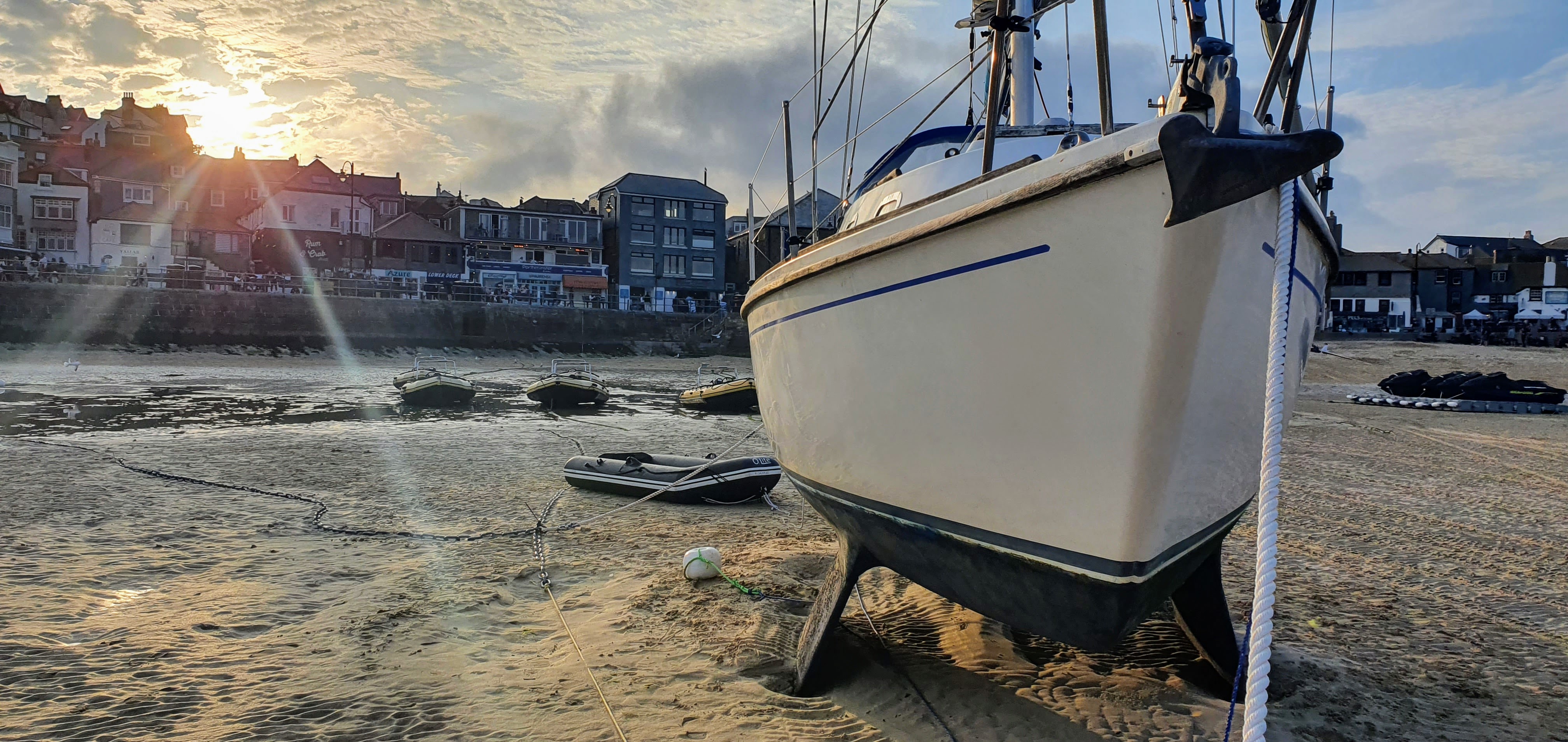
1028: Dropped anchor off St Ives Harbour.
Did attempt to enter the harbour to see if we could pick up a visitor's mooring, but halfway in, the depth sounder was warning there was less than 0.5m beneath the keel. There was one other yacht of a similar size to us in the area of what I thought were the visitor moorings, but uncertain of whether she was actually afloat yet and what the harbour floor was going to do between us and them, we turned back out to sea.

Sat at anchor watching a small open boat with three fishermen net fishing. Every so often they shout at the tourists buzzing around in little hired RIBs to warn them away from their net. They seem very practiced at both the fishing and the fending.
Spoke to the harbour master. There is only one visitor mooring in operation in St Ives at the moment (the other three haven't had their risers attached yet) and the yacht in the harbour is currently sat on it. They are planning to leave at turn of tide however, after which we are welcome to take it ourselves. It's a fore and aft mooring with a single riser for us to grab.

1204: Picked up visitor's mooring in St Ives Harbour.
Dad inflates the tender as the tide drops. Calstar is settled on the harbour floor long before he's finished. We paddle to shore in about two feet of water, not bothering with the outboard, and land on the beach. The seafront is thronged with holidaymakers. The town is absolutely bustling. Other than the fact that every café, bar and pasty shop has a queue outside of about a hundred yards long because of the dramatically reduced seating and mandatory table service in each venue, you'd never know there's a global pandemic.

We head away from the harbour and the crowds into the streets behind and find a relatively quiet restaurant. They find us two seats at their counter. The lack of crowds and queues for a table is explained in part by the prices on the menu and wine list, albeit we were expecting as much.

We order a bottle of the house white, which proves quite acceptable, and the sea bream fillets. The food is excellently done, the fish delicious, and the service friendly, warm and attentive, but the portions a little small for Dad's taste, which looking at the prices on the menu were about what I'd expected. The quantity of food on a plate seems so often to be in inverse proportion to the price of the restaurant's menu.
From where we are sat eating we have a perfect view of the two chefs working. It's a very pleasant couple of hours.

The tide is gone by the time we are back at the boat, Calstar sitting pretty on the sand. The occasional tourist stops to take a photo of her. She unfailingly puts a smile on people's faces as they wander past on the flat sand. And so she should, she always puts a smile on mine.
We scrape the prop clean, and scour the weed and growth from the waterline and foils. Doing so sheds an amount of blue antifoul on to the yellow sands of the harbour floor, so we restrain our scrubbing off to just that. The hull beneath the waterline isn't too bad anyway.

That evening I natter to some dinghy sailors who are rigging their three boats on the tide line to go out and race in the bay. One of them is a Laser sailor, an older gentleman who in the course of our conversation mentions he's recently been diagnosed with Parkinson's. He tells me the sailing club is much reduced in numbers from past glories, but he loves it, and is determined to keep sailing and racing for as long as he can. He tells me the boat he is rigging isn't his, but a club boat.
Thursday 3rd June : St Ives to Carbis Bay
(1.5 miles, 23 minutes underway)

St Ives harbour dries quite close to either side of high water. Heading back up channel, we want to use all of the flood tide that we can, which means, ideally, leaving an hour or two before local low water, when the harbour would still be dry. So to catch all of it, the following day we cast off from St Ives about an hour before top of tide and moved Calstar around to a small bay that sits between Hayle and St Ives, Carbis Bay, and anchored off the bay for the night.

We'd been warned about the prevalence of lobster pots in Mounts Bay, but in all honesty, had barely seen one. St Ives and Carbis Bay were a completely different matter however, and as we came into Carbis Bay, sounding for 10m of depth to drop our anchor in, we came through an absolute forest of buoys, most with a staff and flag attached, the flags typically of a dark material and hanging limp in the quiet air.

We dropped our anchor, that forest of buoys now sitting to seaward of us, an obstacle for the following morning.
It was a pretty sunset and a very peaceful night at anchor.

It was also a very happy accident of timing. Having studiously ignored or avoided the news since leaving home on the 27th, I had no idea at the time that a day or two after our leaving Carbis Bay a select collection of the high and mighty (along with Boris Johnson) were going to commandeer the bay with snipers and warships for their own nefarious ends.
Carbis Bay is quite lovely, but I'm equally quite glad we moved on when we did.
Friday 4th June : Carbis Bay to Padstow
(33.4 miles, 7 hours 30 minutes underway)

Local HW Padstow 1304 5.6m, distance approx 30nm / 8 hours
(0701 - 2.3m / 1304 - 5.6m / 1928 - 2.5m / 0132 5.9m)
Inner harbour gate opens +/- 2 hours local HW

0400: Weigh anchor Carbis Bay
The faintest wolf light is just brightening the clear starlit sky and half a moon is low on the eastern horizon over Hayle Towans beach. Just enough light to carefully pick our way out through the forest of unlit pots. The sky brightens into the promise of a a very pretty sunrise as we make our way out towards Godrevy Light and its off-lying rocks.

0503: Godrevy Light to starboard. 041° COG, 3.5kn SOG, 4.0nm on the log.
0600: Portreath to starboard, motor-sailing under headsail and main. 035° COG, 4.5kn SOG, 7.6nm on the log. Clear blue sky, very light wind on the starboard shoulder, most of it is probably apparent but is just enough to shape the sails. The incoming Atlantic swell makes for a rolling sea.

0800: 50° 26.0N 005° 13.2W, 035° COG, 5.0kn SOG, 16.9nm on the log.
0903: 50° 29.9N 005° 08.4W, 030° COG, 4.5kn SOG, 21.9nm on the log.
The very slight wind has moved astern. Furled the headsail as it kept collapsing and put a preventer on the main; not the proper foredeck to clew rig that I normally use, just a temporary lash-up between the kicker fastening on the boom and the main shroud plate, just to stop the boom swinging inboard every time we get lifted and dropped back down again by the swell.
It's not something I'd risk if there were any kind of significant wind.

Motor-sailing under main alone. There is probably more wind than our own apparent now, but it's being muted by the strong tide that's running with it and us.

1019: Off Trevose Head, 071° COG, 5.5kn SOG. 28.1nm on log.

1130: Against the wall in Padstow's outer harbour, the gate isn't yet open. The harbour master explains that on neaps it's usually late opening. It's later than I expected, however. But we're quite comfortable against the wall. He tells us he'll probably open it when when sandbank outside the harbour finally covers.

It isn't until much later, when I'm working out the passage plan for the following couple of days, that I realise, foolishly, that I failed to add an hour to my tide times for daylight saving. Local HW wasn't due until 1403, so we were early on the tide.

There was no risk. We only draw just under a meter, and I never take chances with the depth unless I absolutely have to, and then there's little to no chance taken because I check my calculations and check them again. And then again, knowing how fallible we are.

And the weather was gentle, the wind light and from a friendly direction, so there was no turbulence over the forbiddingly named Doom Bar at the mouth of the river. Which was as much an influence in my decision to enter Padstow as anything else. And in any case, we followed the pilot notes and the marked channel to scrupulous detail.
But I'm still annoyed that I could make such a silly mistake. At the very least, we could've had another hour's lie in and navigated out through those pots guarding Carbis Bay in good light.

But then we would've missed the pretty sunrise.
Padstow was lovely. A bustling little harbour, right in the middle of town, protected by a sill and tidal gate that opens and closes, according to the book at least, two hours either side of high water.
Once the tide had risen enough to cover the sandbanks outside the outer harbour, the gate opened and we were allowed in. The harbour master directed us to raft up against a Rival 38 called "Rival Spirit" that was moored up against the wall in the far corner of the harbour.

Approaching our new neighbour to be, I hailed them but nobody appeared to stir, so we pulled gently alongside and I stepped tentatively aboard with our lines. At which point a gentleman popped up from below. I apologised for boarding his boat without permission, but he grinned and welcomed us alongside, offering to take our stern line whilst I secured the bow. I offered to rig shore lines, but he assured me there was no need as our boat was so much smaller than his.

Rafting up was perfect for us, as it meant I only had to worry about fendering against John's boat rather than the harbour wall and ladder, and didn't need to concern myself with the slight rise and fall of the tide whilst the harbour gate was open. And John was the perfect neighbour.
A solo sailor living aboard, he'd taken advantage of the recent easterlies to sail down to the Scilly Isles for a week or so, and was slowly making his way back up channel to start a new job on the 14th in, of all places, Portishead Marina.

We spent a fine, sunny afternoon in Padstow, exploring the town, chilling on the boat, enjoying a pint in one of the harbourside pubs, that we later returned to for supper.
Saturday 5th June : Padstow to Port Quin Bay
(5.9 miles, 1 hours 25 minutes underway)

Local Padstow HW 1511 5.8m, forecast 8kn SW, showers.

A preference for arriving at new destinations in daylight meant we again had to cast off and leave harbour towards top of tide and anchor out overnight to make the best use of the following morning's tide. We could have chosen not to have entered Padstow in the first place, I knew by doing so it would cost us a day, but it's a town I've long wanted to visit so seemed a silly opportunity to miss, given we had time and the weather was being so kind.

1435: Dept Padstow, light drizzle, F2 south.
We left an hour before high water, just to give ourselves a bit of contingency getting over the Brea Spit and past the Doom Bar. Incidentally, despite the forbidding name (and not undeserved reputation) of the latter, the name is a corruption of Dunbar, which in turn derives from dune bar.
So the name is a reference to the sand dunes that surround, and not any kind of grim portent or warning. But in the wrong conditions, especially in heavy winds from the prevailing south west, it can be both dramatic and vicious, and has claimed more than its fair share of lives and wrecks, some quite recently.

We were buzzed by a couple of handsome vintage speed boats ferrying joy-riding holiday makers on our way out down the River Camel. We gave them an indulgent wave as they sped past to leave us bouncing in their wake, the occupants cheerfully returning it despite the miserable weather.

Visibility was poor and the sea unsettled as we rounded the small islands and multiple rocks off-lying Pentire Point and the Rumps, and then tucked ourselves back into Port Quin Bay. We entered the bay just after high water, sounding in to just under 10m to allow for a 5m fall of tide, and laid our anchor, adding 15m of warp to our 35m of chain.

Satisfied the anchor was holding, we retired below, the rain unremitting. I set a waypoint on our chart plotter and left it running to keep an anchor watch. It was unnecessary but comforting; although the night was bumpy despite the shelter of the high land close to the west, the holding was excellent.
Sunday 6th June : Port Quin Bay to Lundy
(37.1 miles, 8 hours 38 minutes)

Local HW Lundy 1623 6.6m, approx distance 40nm / 10 hours, forecast less than 10kn westerly
0625: Weigh anchor Port Quin Bay
We woke after a surprisingly good night's sleep to find the rain had stopped and the sea had smoothed. Another yacht had come into the anchorage overnight and was at rest a few cables away to seaward, presumably awaiting enough tide to allow her to enter the Camel and Padstow.
0631: Underway. 50° 35.9N 004° 54.4W, 020° COG, 4.1kn SOG, rain stopped, very light wind bang on the nose. Motor-sailing under main.

0802: 50° 44.8N 004° 46.9W, 023°COG, 3.7kn SOG, 6.1nm on log. Dolphins!
I spotted them first, a couple of them about half a mile away, out towards distant Harland Point off our starboard beam, moving in the same direction as us, breaching and diving as they presumably looked for breakfast.

And then, seemingly spotting us, they turned and sped over in our direction. There was a brief moment when they seemed to disappear, and then one breached close off our port bean, arcing through the water and then diving under our bow.
There were two common dolphins, a large one and another about half of the other's size, and they spent the next ten minutes running alongside us and playing around the boat whilst I danced excitedly around the deck like a kid at Christmas with my GoPro in hand.

0906: 50° 44.8N 004° 49.6W, 024° COG, 3.7kn SOG, 14.8nm on log.
Continuing to motor-sail under main. Light wind off starboard bow, enough to shape the main but not enough to sail.
One day I shall simply cast off and sail, uncaring about making harbour before nightfall or change of tide or by any given day of the week, unfettered by promise or deadline. I'll just let the wind carry me as it will and get to where I'm going when I can.
The journey is so much more than the destination. But you do need to have a destination to have a journey. And for now, my destinations unavoidably come with promises and deadlines.
1020: 50° 49.2N 004° 47.2W, 020° COG, 3.7kn SOG, 14.8nm on log.
1200: 50° 55.6N 004° 44.1W, 023° COG, 4.5kn SOG, 21.5nm on log.
Sky has cleared, wind is very light, sea state slight, sometimes glassy with but the faintest roll of swell. It's turning into a beautify day beneath a warm sun.
1258: 51° 00.2N 004° 41.7W, 016° COG, 5.4kn SOG

We have half a dozen or more dolphins on our bow leaping out of the water and cavorting beneath the boat, an absolute delight. I take photos and shoot video and they just carry on so that, in the end, I leave the camera alone and simply wander about the deck, staring overboard, admiring their sleek grace.

They turn in the clear blue water occasionally as they race past, looking up at me and grinning, seemingly as curious about us as we are about them. They remind me oddly of big, playful, friendly dogs.

Another pod passes astern shortly after our friends finally leave. This third pod seems more intent on finding lunch than staying to play and are gone as quickly as they arrive, arcing across the surface of the water as they disappear into the distance off our port quarter.

1335: A fourth pod pays us a visit and stays to play. I hang off the bow with my camera, one foot tucked under the opposite rail. The sea is smooth and very, very clear. The wind has all but given up, and for once I really don't care.

The dolphins are close enough to touch but I don't. I merely grin stupidly back at them, taking the occasional photo and wiping the salty, fishy spray from my face when every so often one of them breaches beneath me and exhales.

Around 1430 we reach the tidal race off the south side of Lundy. A seal, lying lazily afloat on the surface just outside it, raises its head to watch us with benign curiosity as we pass. It seems a fitting welcome.
We are earlier on the tide than I expected, but it is calm, except for swirls and eddies, although moving very fast. We crab our way through it, angled into the flood 45° from our actual course. The island seems deceptively close with its tall cliffs and high green slopes as the anchorage opens up to us.

1503: Drop anchor Lundy.
I've wanted to come to here for years. It's so good to finally make it. Even if we did have to motor all the way. At least the conditions in the anchorage are absolutely perfect. We have a few other boats already here for company and another arrives from up channel a little after us; my only slight concern is not wanting to anchor too close to them, nor get to close to the rocky shore.

As I open my sole can of Heineken to celebrate our arrival, Dad begins to inflate the tender. I should stress that I'd happily do it myself, but he insists every time, as if I've somehow exhausted myself with the navigation and pilotage.

With the tender inflated and afloat, I fit the outboard and, the tide now turned and the anchor clearly holding in less than 10m of water, we head to the landing and climb the long, high path to the small settlement atop the island.

The climb is slow and leisurely, we take our time to take in the gorgeous seascape that is unfolding beneath us. We pass the occasional person or two heading down in the other direction. Most are camping on the island or staying in the few rustic lodges the National Trust maintain on the island, having arrived on the MS Oldenburg, the island's own supply ship. All are friendly and some occasionally stop to chat as we climb and they descend.

We reach the Marisco Tavern. We're made welcome, but with the ever prevalent Covid restrictions limiting seats, they can't feed us as the island's resident guests, the lodgers and campers take precedence. We're welcome to a drink, and we order a couple of beers along with paying the £7.50 landing fee, but we're told we'll need to leave so as to vacate our table by 1800, when their first diners will arrive for their supper.
That gives us about an hour.

We drank a couple of beers each, and then headed back down to the boat where we enjoyed a bottle of wine from our own stores, and Dad cooked a perfectly acceptable supper of penne pasta along with a tin of meatballs in BBQ sauce.

Monday 7th June : Lundy to Ilfracombe
(21.9 miles, 4 hours 10 minutes underway)

Local Lundy LW 1059 1.8m
Ilfracombe HW 1714 8.0m, LW 2211 2.1m
My original plan, so as to not lose another day waiting for a tide, was to anchor off Coombe Martin, a village set in a small bay about 6 miles east of Ilfracombe. The weather was still calm, and it would cut about an hour off the next day's passage to Cardiff and Penarth.

1049: Weigh anchor Lundy
Knowing we won't be able to sail, that the weather will stay, and we will want the tender when we arrive at our anchorage, I break with my usually iron-clad habit and elect not to partially deflate it and stow it on the coach-roof, and instead tow it astern.
I feel slightly dirty doing so, but pragmatism prevails.
1129: 51° 10.6N 004° 35.0W, 082° COG, 4.6kn SOG, 2.9nm on log. A bit of swell, no significant wind, less than F2 westerly. Motor-sailing with headsail.

1209 51° 11.5N 004° 30.3W, 082° COG, 4.7kn SOG, 6.0nm on log.
Not enough wind to support the headsail even without the cover of the main, so have rolled it away. Running on engine only now, throttle at a comfortable 2k revs. Well, as comfortable as running under engine ever gets.
1300: 51° 12.12.N 004° 23.7W, 084° COG, 6.0kn SOG, 10.2nm on log.
1400: 51° 13.4N 004° 14.8W, 087° COG, 6.4kn SOG, 16.0nm on log.
Bull Point to starboard, the race is quiet, sea calm and a hazy sun shines through a light overcast overheard. Another beautiful day and we remain a humble power boat upon a windless sea.

Passing Bull point brought us back out of unknown waters and back into our home ground. Every mile from here up channel as far as Gloucester has been well sailed by us over the years, albeit we've only taken Calstar up to Gloucester via Sharpness and the canal; we've only explored the river up channel from there with the old Drascombe Lugger, or with various club dinghies I borrowed back when our adventures were based out of Lydney.
I'm really looking forward to going back there again.
So these waters are known, but that's not an excuse for complacency, for here be dragons too even if for now they lie quiet.
But not many more miles now before we can stop looking out for pots. The tide would wash any away if a fisherman were to try and lay one. Of course, we'll still have to keep a wary eye out so as to dodge the occasional tree, or gas bottle, fridge or even the odd car that might get carried away by the Severn tide.
The waters still remain blue and haven't faded to a silt coloured hue yet. But soon, only another day.
Passing Ilfracombe I have an epiphany. The visitor moorings in their outer harbour only dry at around 4m. We're still closer to neaps than springs. A quick call through to the harbour master confirms there are a couple of moorings free, and he doesn't expect them to dry out until around 0900 tomorrow, a good couple of hours after we'll need to be gone if we're to make the tidal gate between Flat Holm and Lavernock Point.

We abandon the idea of anchoring in Coombe Martin Bay in favour of a visitor's mooring and restaurant in Ilfracombe. We are lazy sailors.
1459: Picked up visitor's buoy, Ilfracombe.

We are alongside another Westerly Griffon, out of Porlock Weir. I've only been to Porlock once, and the harbour master, a gregarious fellow called Pud, got me very drunk at the local pub. I would like to go back, but Dad's never been especially keen.
Turns out the skipper of our neighbouring boat is Pud's cousin.

We natter for a while, comparing notes on Griffons and recollections and anecdotes of Porlock, then Dad and I head ashore to find a beer and some food. We have a drink at the local Weatherspoons; despite despising the chain and the owner's politics, the beer is cheap, unfailingly well kept, and I am weak.
Then we retreat to a harbourside restaurant called Smugglers where I have their grilled prawns and Dad has their cod and chips. We often eat here when in Ilfracombe, it's friendly and welcoming and the food always good.

We are fed and back at the boat before she's taken the ground with the tide, so use the tender to paddle back from the harbour wall. I sip beer and read in the cockpit as the sun goes down and the charter fishing boats and tour boats return to their moorings. The harbour is quiet and peaceful as Calstar finally settles down on the sand with them for the night.
Tuesday 8th June : Ilfracombe to Penarth
(42.9 miles, 10 hours 5 minutes underway)


Local HW Cardiff 1846 11.1m, distance 40mn / 10 hours
0700: Drop mooring, Ilfracombe

1000: 080° COG, 2.1kn SOG, 6.3nm on log, 2nm west of Woody Bay.
We're expecting foul tide until noon. Motor-sailing under main, morning is calm and the sea smooth. Slow going against the tide, but we stay inshore to avoid the worst and enjoy the stark, dramatic cliffs and bays of the North Devon shoreline.
1148: 51° 22.7N 003° 10.6W, 070° COG, 3.3kn. Best guess 13nm on log.

My watch crashed a short while ago when I plugged it into a battery pack to charge. Unplugged the watch from the charger then switched it off and back on again before plugging it back in and restarting the log which, of course, has reset to zero, splitting the track. We are 2nm north of Lynmouth, approaching Foreland Point.
Distances logged for rest of day will be from here. I'll add the rest on when we get to our destination.
1300: 51° 22.7N 003° 10.6W, 066° COG, 4.5kn SOG, 5.0nm on log

Tide is turning fair. Sky is beautiful, sea glassy, with a slight undulating swell coming up with the tide.
1418: 51° 19.4N 003° 29.4W, 073° COG, 7.1kn SOG, 12.7nm on log.

Dad spots Steep Holm on the far distant, hazy horizon. Now he's pointed it out, I can just make out the silhouette of Flat Holm off to its left, but it's still too far for him to see. Home ground.
Still motor-sailing under mail. The tide has us, like a big magic carpet. Sea is still a greenish, translucent blue. Sun is warm.

1454: Light wind on starboard beam. Motor-sailing under headsail and main. We are on a line between Breaksea Power Station on the north coast and Minehead on the south. The sea, as expected, is beginning to silt up, tannin patches claiming the gorgeous green blue it has been until now.
We can feel the grip of the tide swirling and eddying beneath us.
1500: 50° 20.6N 003° 21.8W, 080° COG, 8.0kn SOG, 17.6nm on log.

Two porpoises just sighted, about a cable off our port beam, between us and Breaksea, arcing through the water as they swim down channel against the flooding tide. Only a brief glimpse and they are gone, ignoring us. I didn't expect to see them up here, it's only the second time I've seen them so far up channel.
Only the briefest of a glimpse, but they leave a lingering grin plastered across my face
I tell Dad life is better with a porpoise. He rolls his eyes.

1554: 066° COG, 7.5kn SOG, 24.5nm on log. Sully Island on our port beam. We give it a good offing to avoid the inshore counter-eddy that will be running back against us.
We round Lavernock Point inside of Flat Holm, turning into the Penarth Roads. The grip of the tide eases a little. We lower the main, furl the headsail, prepare the lines and fenders and call up the lock to request entry.

A friendly Welsh voice replies, directing us to Lock #1 for 1645. We enter the Wrack Channel and make our approach. As we're about to enter the outer harbour a couple of boats are leaving. One is the yacht "Darteign", helmed by our friend Eric of Lydney Yacht Club, albeit I think he now keeps Darteign in Cardiff these days.

He doesn't notice us, or at least recognise us, as we pass, he's too busy sorting his lines and fenders. He's heading back the way we've come, on his way to Falmouth. I expect he'll get there a lot quicker and with fewer breaks than we got here from there. Eric and Darteign made an attempt to sail from Lydney to Argentina at the beginning of last year. Unfortunately, Covid trapped him in a Spanish marina for months before the restrictions were lifted enough for him to sail home, and so scuppered his ambitions.
1705: Alongside a visitor berth in Penarth Marina.

Locking in through the Cardiff Barrage was just like old times. It felt as if we'd never been away.
Home ground.
We had supper in the Old Custom House, which I think was the last place we ate in before we left Penarth for Plymouth. It hasn't changed. Lovely venue, food cooked to perfection, a little bit pricey, portions a little bit to small.
Dad had a sirloin steak, I chose a crawfish tail cooked in garlic butter. Both came with chips, and we shared a side of steamed broccoli and sautéed asparagus. Dad thought the broccoli was undercooked. But "steamed" is always crunchy, and personally I prefer it that way.
He's right about the portion sizes though. If they'd but doubled the small handful of chips they gave us to share, for such a small cost as an extra potato or two Dad wouldn't have left still hungry.
Wednesday 9th June : Penarth to Portishead
(18.8 miles, 4 hours 40 minutes underway)

We indulged in a cooked breakfast at the café overlooking the marina. It used to be a favourite of ours when we were based in Penarth, and the breakfast menu remains the same, the food just as good.

I then killed the time waiting for the tide with a walk over to the Outer Harbour, down onto the beach and then scrambled along the pebble shore under the cliffs to the Penarth promenade.

I walked up to Penarth Yacht Club, all shut up early morning mid-week. I raced our Enterprise here once back when my friend Hels used to crew with me. A two day event, our first time sailing together on anything resembling the sea.

We capsized in the wind and waves, somewhere out where they'd laid the course in the Penarth Roads. And broke our mast in the recovery.

That evening the locals found an Enterprise in the boat shed that wasn't racing for the event, contacted the owner for us, and secured us the loan of another mast so we could still race the second day. Given what we'd already done to our own mast, that struck me as an amazing act of trust and generosity. Wonderful club, PYC. Really hope to race there again one day.

1337 Alongside Lock #2 Cardiff Barrage

Tide is low, and it's a long, long drop down to the Bristol Channel from the shelter of Cardiff Bay.

We leave the lock and outer harbour and make our way out into the mud-banked shallows of the Wrack Channel. There is 0.5m of water beneath us, allegedly. But with this much silt in the water, the sounding is not reliable. But the tide is rising. We tentatively pick our way down and out of the dredged channel and into the Penarth Roads.

1403: 065° COG, 2.7kn SOG; sails up, engine off.
Wind is an optimistic F2 on the starboard beam. Most of our speed over the ground is tide. Which, because I've charted a course around the northern side of the Cardiff Grounds, is going to take us to Newport if we're not careful.

1500: 086° COG, 3.3kn SOG. Close hauled on starboard. Yellow "Diffuser" Buoy north of the spoil grounds is just off to port. Wind remains an optimistic F2 but is heading us as the tide takes a grip. Sea is completely flat. And the colour of builder's tea.

1520: 51° 27.6N 003° 03.1W, 095° COG, 5.4kn.
The tide is definitely dragging us up and into the Newport Deep. The best I could hope for would be to hit the still high and very visible sands of the West Middle Ground. I tried tacking, the angle was huge because of the tide, but I was encouraged as the sails set and the boat settled on a port tack to see we were logging 1.5kn over the ground.

Then I checked our track on the plotter, and realised it was 1.5kn backwards, still in the direction of Newport.
I caved into the inevitable, furled the headsail and started the engine. We're now motor-sailing and aiming at the Clevedon shore on the far east bank.
1607: 099° COG, 7.6kn SOG, motor-sailing, entering the Bristol Deep.

Had to slow down to let a big, lumbering car carrier called "Viking Amber" go past, inbound to Royal Portbury. Keeping a listening watch on Bristol VTS on VHF 12 gave us plenty of warning he was coming up, and tells us another is coming out of the port and down our way.

I decide to keep the engine running and hold our course until we're over to the east side and clear of the narrow shipping lane called King Road. Then I'm going to sail the last bit home. Regardless of what the wind thinks it's doing.

1633: Engine off. Wind F2 on our port quarter. The other big car carrier is coming down the shipping lane, but we're safely out of it. The starboard lateral "Avon" is a cable or two off to port.

069° COG, 4.3kn SOG, 13nm on the log

1704: Flat calm, engine on, sails down. Very easy drop, the second we start the engine and engage the throttle on little more than tick-over, the wind is is directly on the nose.

057° COG, 7.7kn, 15.3nm on the log. We are almost home.


1816: Alongside our new berth in Portishead. Calstar is home.
28th May to 9th June : Plymouth to Portishead : Summary
283.9 miles over 11 stops, including 3 nights at anchor
66 hours 13 minutes underway

A little bit too much of the time for my taste was under engine rather than sail, but really, the weather was exceptionally kind so I can't complain.
So it was also an exploration. We stopped in harbours, towns and bays that are, more often than not, too far to reach with the time I have for reasons of either distance or weather. That was, for me, a big part of the reason for doing this.

We took the ground in St Ives, crossed the Doom Bar to reach Padstow, landed on Lundy and spend the night at anchor in Lundy's Landing Bay.
There will always be dragons out there, and I know they'll always be ready to bite, but now we know them just a little bit better.
And by bringing her back ourselves, I feel we've in some part made it up to our little boat for the indignity of shipping her down south on the back of a lorry. If, or rather when, we take her back down there again we shall sail, or we shall not go until we can.

But for now, she's only half an hour down the road from our front door. She's back. And I do love the Bristol Channel. The tides, the challenge, the other boats and people we meet, all of them just a little bit mad just like us, because you have to be to love these treacherous, silt laden waters so.
Oh, and the sky. The Bristol Channel skies. I think it's something to do with the funnel formed by narrowing land both north and south of an east-west running sea, with the might of the Atlantic pushing ever down her throat.
And, funny enough, the tannin, silted hues of her waters.

They conspire to create a sky-scape, especially when set against a westering sun, like none I've ever seen anywhere else.
Calstar has come home.
No comments:
Post a Comment